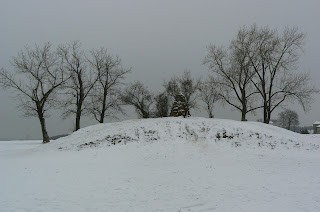
During the week I had to take a quick trip to the hardware store in Prague, which is right next to the Battlefield of White Mountain. I had been promising myself to go out and take a few snaps for months now, so once I was there and had finished the shopping I gritted my teeth and got on with the job at hand (considering it was about -14 centigrade, and snowed in). Rather fitting for the last stand of "The Winter King".
For the uninitiated, a potted history. The Battle of White Mountain was the main engagement at the start of the 30 Year's War, which began when a few catholic councillors, and the representatives of the Catholic claimant to the Bohemian Crown (Ferdinand of the House Hapsburg) were turfed out of a window at Prague castle, and Frederick Falkenberg of the Palatinate (a protestant) was declared King of Bohemia, thus ousting the Hapsburg claimant. This upset the balance of power at the time as the King of Bohemia was one of the seven electors who elected the Holy Roman Emperor (the nominal ruler of all the German states, plus a few "extras"). With Frederick sitting on the Bohemian throne, it raised the possibility of the next Emperor neither being a Catholic or a Hapsburg. The Pope, the Spanish, The Austrians, The Bavarians and even the Lutheran Saxons were not willing to wear this, so their armies marched and eventually pitched up in front of Prague. A largely untried, unpaid and so unmotivated army was what Frederick fielded to oppose them, and apart from a number of Moravian regiments on the right wing who stood for most of the battle, the rest of the army was fairly quickly swept from the Field, by the catholic league regiments made up of many veterans from the battlefields of Flanders.
Rumour has it that René Descartes was present at the battle, or as one old friend put it, maybe he just thought he was there...

Now the store I visited actually sits atop the position of the right wing of the Imperial/catholic league troops during the Battle of White Mountain. This part of the battlefield is mostly built over and consists of the suburb of Repy.
The road above marks roughly the axis of the right wing of the Imperial Army, where it attacked the Bohemian left flank.
And running west from the main road, the route up the spur of the hill that the Imperials took (it's hard to see but there is a slope).
The best guide to the battle and battlefield is the book "Černý Den na Bílé Hořé" (which translates as "Black Day at White Mountain") by Dusan Uhlir. The day is seen as one of the darkest in Czech history, hence the title, with the assumption of total Hapsburg power over Bohemia and it's throne up to the end of the First World War. The book itself is an excellent guide to the battle and disposition of the various forces.
As mentioned, the weather was pretty grim, I imagine not too dissimilar to the actual day of the battle on 8th November 1620. Easy to see how unpaid levies might decide to run. I went over to the centre/right wing of the battlefield, which is still open land, with the main monument to the battle in the middle. This is a fairly bleak field on the best of days, at the cusp of a large plateau facing west and usually buffeted by wind.
The field is surrounded at the edge by villas mostly built in the 1920's, the whole area being open countryside up to that point.
Above is the monument, looking from south to north along the axis of the Bohemian position
Even from here you can make out the slope to the high point, while to the west the slope drops away fairly steeply.
Looking west towards the approach of the Imperial forces (where the Catholic League terciosunder Tilly marched up the hill). You can make out the camber of the slope as it starts to drop away. The houses are only 200 metres away but you only just see their roofs which gives you an idea of the gradient. In 1620 it was probably more pronounced. (In the distance you can see Prague Airport)
The sign standing up on the ridge in the distance is the site of the hardware store, and where the Imperials began to roll up the Bohemian left flank (it's about 800 metres to the south-west from the monument in the centre of the battlefield).
Looking north from the memorial towards the Star Palace, the last stand of the Bohemian army. This building is largely as it appeared in 1620, and the walled forest around it is still intact.
Looking north along the remaining axis of the Bohemian position towards the Star Palace. The land again drops away sharply here before rising again at the Palace. For the Bohemians to maintain this position, they had to follow the curve of the Plateau, making the centre an exposed salient (that noted though, the Bohemia army collapsed from it's left flank - by the hardware store, and was rolled up to it's right flank at the Star Palace)
The monument was erected just after Czechoslovak independence, on the 300th Anniversary of the battle in 1920.
Below you can see the Church of Holy Mary Victorious which was built next the the battlefield between 1622 - 1624, and marks the beginning of the bloody Counter-Reformation.
The battlefield is easily reached from the centre of Prague, with large parts of it still open (especially the centre, and north by the Star Palace).


