As Tuesday (8th January) will be the 201st
anniversary of the start of the siege (and eventual storming) of Ciudad
Rodrigo, I thought I would dig out my notes and pictures of my visit. Coming
from the south, you drive over mountain passes, plateaus and open moorland
before descending down towards Ciudad Rodrigo. The land is beautiful, empty,
and mostly poor. It reminded me very much of the west of Ireland.
You
can see Ciudad Rodrigo from a fair distance as you approach, clearly dominating
the main northern route between Spain
and Portugal.
Thus the reason for it’s and Badajoz’s importance to the overall strategy of
the war. An army would have to hold both of them to have any chance to either
successfully defend and/or invade, in either direction. Only when wellington
had secured them both was he able to advance into Spain. As it was Wellington
chose to invest Ciudad Rodrigo first.
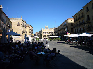
Ciudad Rodrigo itself is in remarkably good shape, and seems
little altered from the time of the siege (unlike Badajoz). It is mostly built
of sandstone, with many baroque as well as medieval and renaissance structures
and churches crowded around the two main squares. It is easy to find the point
of the main breach as all the buildings in it vicinity still bear the mark of
cannon shot, the main church resembling a pepper pot with all the holes in its
façade.
Here you can see where the British siege guns reduced the
bastion by half, compared to the surrounding walls. This was the main breach stormed by Picton's division.
Here is the site of the lesser breach, stormed by the Light
Division, and the where General Craufurd’s body was interred after the battle.
And the memorial marking his final resting place.
Here in the distance you can see the Grand Tesson, upon which the British
siege guns were sited, and behind which the Picton’s 3rd Division
sheltered before storming the town.
The hill overlooks the town, so the French had sited a
redoubt here to prevent it being used as a siege point by the British. This had
to be stormed first by Crauford’s Light Division on 8th January 1812,
after which the siege guns were set up.
I didn’t manage to get up to it as it is across several fields of fenced off farmland (though I am sure there is a track somewhere). I did though drive behind the hill, and it is easy to see how the British divisions could be concealed here, masking the preparation for any attack.
I didn’t manage to get up to it as it is across several fields of fenced off farmland (though I am sure there is a track somewhere). I did though drive behind the hill, and it is easy to see how the British divisions could be concealed here, masking the preparation for any attack.
The Grand Tesson looking up from the Lesser Tesson.
The main breach viewed from the Lesser Tesson. It's easy to see how the church tower became riddled with shell holes.
The lesser Tesson, where the British siege lines were pushed
forward for the final bombardment and storming is easy to reach, being just
outside the city walls, though half of it is covered in apartment blocks now,
and a small railway line cuts it off from the Grand Tesson.
The outcome was never in dispute as the town was essentially
indefensible with such a small garrison. Once the French had lost the Grand
Tesson, the game was up. What is less easy to understand is why the French
garrison did not surrender.


Great photos thanks for sharing them!
ReplyDelete